Wednesday, August 31, 2016

#112 Jun 2015 Newfoundland and Labrador - Wow!

We spent three amazing weeks in Newfoundland Labrador and I have to emphasize that it should be on everyone’s “Must See” List if at all possible.

The geology is ancient beyond human comprehension. See post #106.


The scenery is dramatic.


The wildlife is fascinating.

June was a great month to see icebergs and puffins but early to see many whales.


The European history is the oldest in North America. See post #108.


Many firsts occurred in Newfoundland and Labrador.


The people are enormously friendly and helpful to everyone.


As we were waiting for the ferry back to Cape Breton I chatted with a Newfoundland couple who gave me this souvenir of their home.


Our hostess, Mary, in L’anse au Loup gave us personal insights into life in Labrador over the last 80 years.


Local entertainment is unique to the Island.


Cod fishing provided the first explorers and settlers their livelihood and was the mainstay for centuries. Cash was scarce and the economy operated largely on a system of credit where cod became known as “Newfoundland Currency”.


When Newfoundlanders talk about fish it is cod. All other fish are named, but cod is just “fish”. No further name or explanation needed.

The 1992 moratorium on cod fishing was a crippling blow to the Newfoundland economy. However, its people are resilient and looked toward another source of wealth from the sea – oil. The Hibernia Oilfield brought jobs to the province and a renewed sense of hope for the future.


Fort McMurray Oil Sands provided long distance jobs.


Newfoundlanders and Labradorians are determined and resourceful people and will go to great lengths to maintain their unique lifestyle and traditions.


Newfoundland Labrador was the highlight of our “Circle Tour of the US and Canada”.

Thursday, August 25, 2016

#111 Jun 2015 St. John's NL Really Old!

From Bonavista Peninsula we headed to St. John’s on the far eastern tip of the Avalon Peninsula.


In 1497 John Cabot sailed into what is now St. John’s Harbour. The following is a replica of the Matthew built for the 500th anniversary of his landing.


St. John’s has been crucial in the defense of eastern North America and the North Atlantic. From the beginning of year round settlement in 1630 there have been British, French, American and Canadian military presences and battles including the First and Second World Wars.


Signal Hill overlooks the Narrows leading into St. John’s Harbour.


Cabot Tower was constructed on Signal Hill to celebrate the 400th anniversary of Cabot’s arrival.


In 1901 Marconi received the first transatlantic wireless signal in a vacant wing of the Diphtheria and Fever Hospital near the Cabot Tower.


Signal Hill rocks existed before almost all forms-of-life on earth.


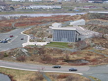
Johnson Geo Centre is cut from the ancient rock of Signal Hill and presents an impressive story and display of the evolution of our planet Earth and its people.


The Geo Centre explains:

Our place in our solar system 


Exploring our solar system


The geologic history of the earth (see post #106 for more info)


The movement of humans over millennia (see post #108 for sculpture of east meets west)


An incredible overview of the story of the Titanic


The evolution of the Hibernia Oilfield.


St. John’s is one of the oldest settlements in North America and Water Street is the oldest street in North America.


Jellybean coloured houses cling to incredibly steep, twisting streets.


Downtown George Street boasts two blocks of nothing but restaurants and pubs. Vehicles are allowed in the morning for restaurants and bars to replenish their stocks. After that pedestrians are free to wander and explore the flavours of the establishments and their buildings.


In 1989 the port recorded 1,000 commercial ship arrivals representing 22 nationalities.


Over more than 500 years St. John's has endured possesion by many nations, wars, changing economies, unstable sources of wealth and still possesses the charm and hospitality for which Newfoundlanders are renowned.

Tuesday, August 9, 2016

#110 Jun 2015 Puffins!

When we returned to our RV parked in Rocky Harbour we found that the fridge had failed to stay cold. Before we left for St. Anthony we knew there would be a power interruption. The fridge should automatically switch to propane when there is no power available then return to power when it comes back. Something didn’t happen correctly and we had a fridge full of warm food.

When we leave the RV plugged in we assume all will be well, especially the fridge. That was a learning experience we have kept in mind since then. Now when we leave the RV overnight we have as little food in it as possible.

After we re-stocked the fridge we took a long look at the points of interest we expected to see in Newfoundland.

This map provides some insight into the size of Newfoundland and the few roads available.


There are only two ferries to Newfoundland. We were there in June and took the year round 6-hour ferry to Channel-Port aux Basques.

In July and August the 12-hour ferry runs to St. John’s on the southeast corner of the map. That would allow a circular trip but was not an option in June.

We realized our only choice was the same ferry as we arrived on from Nova Scotia. That meant we would retrace our trip from St. John’s to Channel-Port aux Basques, a distance of 900 km. That is the Trans Canada Highway winding through the centre of Newfoundland.

We had spent nearly 2 weeks 
from Channel-Port aux Basques (southwest corner of the map)
to Rocky Harbour (midway on the west coast)
to St. Anthony and L’Anse Meadows (the northern tip)
to Labrador
and back to Rocky Harbour.

We had to choose our next explorations leaving time to return to the ferry within the three weeks we had allotted in Newfoundland.

Puffins were a must see for me. That meant our next destination would be Bonavista Peninsula, midway on the eastern side of the map.

We headed out with our “trusty” GPS. Occasionally it is not so trusty and takes us unexpected places. This time the directions took us to a local farmyard where a surprised family watched our arrival. As we approached the house we knew we were not at an RV park but couldn’t change course in the middle of a narrow road. Some phone calls cleared up the directions but Ralph had to unhitch the car since there was very limited room to turn around. Fortunately it was late afternoon with lots of daylight left and we did find our intended park.

In the small community of Elliston this Sealer’s Memorial poignantly depicts the dangerous reality of life at sea.


In the evening, puffins come in from the water to their summer homes atop steep seaside cliffs.


They spend most of their lives at sea and look awkward on land.


They nest in protected holes hidden in the grass.


These small, comical birds bring a smile to everyone as they go about their evening business.


It was a special treat to see the puffins in their natural habitat. The steep cliffs keep them protected from predators and intruders, such as humans. A camera zoom lens or binoculars are necessary to view them.

Elliston is the root cellar capital of the world. Hundreds of these man-made, frost-free food preservers – many still in use – recall the ingenuity of the pioneers.


A beautiful ending to a magical visit with one of nature's clowns.